


5-30-17
.
.


clearfieldreunions.com
Clearfield, PA
Daisy Street Wall, 1940's to Today ~
Back to Reunions home
|
.jpg "EEWallPic (1)")
www.clearfieldreunions.com149.56.187.129
ypmhqrv ~6g!dJ.]L)G_
ypmhqrv ~6g!dJ.]L)G_
Click any picture to enlarge
Any time you turn right onto Clearfield's Daisy Street from Bigler Avenue on your way out into the
East End, on your your right is an imposing stone wall for about half of the block that is a small
part of a larger story. If you've ever wondered why buildings on Bigler Ave. out as far as Jason Unch's
"Full Throttle Signs"carry a Bigler Ave. address while the Mall and everything beyond to the Clearfield
Creek bridge are considered Daisy Street, I'm going to try to provide an answer.
Prior to WWII Daisy Street was the main thoroughfare through East End and at that time was actually
US322. Back then Daisy St. did not unceremoniously end at the back door of Denny's Pub (MAP) as now
but continued straight on through to roughly the same alignment as today's Daisy Street Extension. The
construction of the 879 bypass in the 70s finally resulted in Daisy ending where it does now but earlier
projects had quite an affect as well.
Around 1940 it was apparently decided that Daisy was too narrow and congested for its role of a main
highway but didn't lend itself to much of an upgrade with homes and businesses on either side and the
solution was to widen and improve Bigler Avenue to the alignment we're familiar with today.
Here are some photos and I'll try to document what's going on as well as I can:
This picture has a handwritten note at the bottom in my
Aunt Lillian Eshelman's writing that says:
"Grandma Ds house, corner of Bigler and Daisy St,1940."
The "Grandma D" would have been my great-grandmother
Dietzel who with my great-grandfather owned the house,
which today we know as the Siegel Engraving premises.
Looks like the construction of the new Bigler Ave. also
nearly resulted in the loss of the back porch and steps to
allow for the public sidewalk.
|
.jpg "EEWall17 (7)")
|
|
||
|
.jpg "EEWallPic (3)")
.jpg "EEWallPic (4)")
.jpg "EEWallPic (2)")
Below, the left picture shows the new Bigler Avenue (note says "New Road") with the homes on Elk
Avenue (also referred to then as the "Tannery Row") and the house more recently the Lingle TV Repair building (with the somewhat odd roofline) in the background. The other shows Daisy Street diverging
from Bigler Ave. with excavation to the bank preparatory for the Wall on the right. This picture also
shows three houses, the farthest one being 315 Daisy St., the center one now long gone and the one on
the extreme right still standing just at the top of the stairs in the wall in later photos.
This is another view of the "Grandma D/Siegel"
house, taken from the South side of Daisy Street
as though your back was to the current wall. It
looks that lots of concrete from the street has
been torn up in preparation for new pavement
house, taken from the South side of Daisy Street
as though your back was to the current wall. It
looks that lots of concrete from the street has
been torn up in preparation for new pavement
|
.jpg "EEWallPic (6)")
This view is of Bigler Avenue looking East at the
back of my 316 Daisy St. property. The fire hydrant
pictured is where it has always been but the curb
and sidewalk were both moved north to conform to
the realignment of the street with its gentler turn.
So, while "Grandma D" almost lost her back
porch, 316 Daisy got about 6' added to the back of
the property for Cliff to mow. Lucky me.
As Bigler Ave. continued east - think particularly
about 6th to around 9th street - the widened road
ended up right against those properties.
|
.jpg "EEWall17 (5)")
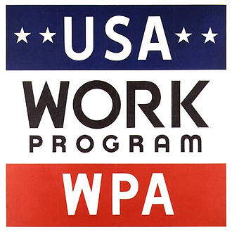
The Works Progress Administration (W.P.A.) was the
largest of President Roosevelt's New Deal agencies,
formed with the mission of putting people to work
during the depths of the Great Depression. It was
started in 1935 then disbanded in 1943 as the war
effort eased unemployment.
largest of President Roosevelt's New Deal agencies,
formed with the mission of putting people to work
during the depths of the Great Depression. It was
started in 1935 then disbanded in 1943 as the war
effort eased unemployment.
|
|
||
|
|
||
|
.jpg "EEWall17 (1)")
.jpg "EEWall17 (2)")
.jpg "EEWall17 (3)")
.jpg "EEWall17 (6)")
.jpg "EEWall17 (8)")
Much of the Wall is still in pretty good shape even
at 75 years old, but the lower reaches toward the
Bigler Ave. end seem to be showing the stress of
the overburden pushing it outward.
at 75 years old, but the lower reaches toward the
Bigler Ave. end seem to be showing the stress of
the overburden pushing it outward.
|
.jpg "EEWall17 (9)")
This one has always puzzled me. Apparently the Gas Company
thought this was just a wonderful way to get their product up
to a new customer. To me, not so much.
thought this was just a wonderful way to get their product up
to a new customer. To me, not so much.
|
.jpg "EEWall17 (4)")
|
.jpg "EEWall17 (10)")
|
.jpg "EEWall17 (11)")
So, to recap ~ up until the early 1940's Daisy Street was designated US 322 - "The Lakes to Sea Highway",
Cleveland to Atlantic City, while Bigler Avenue was more or less an industrial street, serving the Brickyards,
the Elk Tannery, the Rail Yards and so-on. In the immediate pre-war period, 1940 into the war year of
1942, Bigler Ave. was transformed into a proper highway while Daisy St. retreated into a more leisurely
existence, serving the residences, taverns, and mom & pop stores that dotted its length.
Back to Reunions home
Click for more
infornation.
infornation.
|
|
.jpg "EEWall2052817 (4)")
.jpg "EEWall2052817 (3)")
|
.jpg "EEWall2052817 (2)")
Bigler Avenue today from the same perspective. From the >
pink survey flags, looks like PennDOT is planning a
project. Hope they sweep the winter's accumulation of
"anti-skid" off ot the sidewalk at the same time.
pink survey flags, looks like PennDOT is planning a
project. Hope they sweep the winter's accumulation of
"anti-skid" off ot the sidewalk at the same time.
An interesting aside is that the house next door to mine, 312 Daisy Street had once been 311 Bigler Avenue,
owned by my grandfather who apparently felt that transforming the back into the front allowed him to
retreat back to the now less traveled residential street. As mentioned before, 304 Daisy, Siegel's, had once
been owned by my great-grandparents as was all of the property up to the alley to the right of my house.
The lot containing 312 was conveyed to my grandparents, the lot between 304 & 312 was sold to a gentleman
who built the duplex ( 308 & 310 ) that stands there now, and 316, my house, was conveyed to my Dad in
the 30's and to me in 1976. MAP
Daisy Street continued out to its confluence with Bigler Avenue just west of where the bypass is today
until around 1970 when Woodland Road was reconfigured to create a more orderly intersection with
Bigler Avenue and it then was terminated just behind where Denny's is now as mentioned above.
Then the bypass came along around 1976-77 and shook things up even more.
There is one thing that I'm not sure about and that is ~ Why when it was decided that the emphasis be
placed on Bigler Avenue as the primary artery through East End was it also decided at the same time to
build that big wall on Daisy Street when it was in the process of being deemphasized? I'm guessing that
the wall or terracing along Daisy had been needed or at least considered for a while and the attitude was
to just do everything at once and get it over with. I also don't know if the whole Bigler Ave project was
a W.P.A. undertaking or just the wall itself. But at 75 years old the wall is starting to show its age and
I personally wouldn't mind seeing it rehabilitated instead of that idiotic project being planned for down
on the Texas border.
Whatever happened or happens, there was never a better place off of which to bounce a tennis ball while
growing up. At least until Chief Edmiston came driving by.
|
|
.jpg "EEWall2052817 (5)")
.jpg "EEWall2052817 (8)")
This is my grandparent's house, above, when it was 311 Bigler Ave. with just a small back "stoop" on the Daisy Street side. The note says "Dot & Laura" , two of my other aunts. Judging by Aunt Laura's age in this picture, I'm guessing it was taken around 1916.
This other picture, right, undated,was taken later after it had
the larger front porch added and had become 312 Daisy St. >
the larger front porch added and had become 312 Daisy St. >
316 Daisy Street >
|
.jpg "EEWall2052817 (7)")
|
.jpg "EEWallPic (5)")
Now this is really interesting ~
This house must have been to the right of the house
in the right of the above picture, perhaps on the very
promontory of the hill below the cemetery. It looks
as though either a porch or an addition has been
removed and judging from the steel I-beam in place
underneath that it is in the process of being moved.
Which would be quite an undertaking even now,
let alone in 1940.
|
.jpg "EEWall2052817 (1)")
From a similar perspective today. While the
building today has an entry door facing
out onto Daisy St., earlier it had two,
one on the west facade and one on the east.
building today has an entry door facing
out onto Daisy St., earlier it had two,
one on the west facade and one on the east.
Here's a picture that has absolutely nothing to do with the subject at hand and I'm including
it only because it was with all of the other old ones ~
it only because it was with all of the other old ones ~
|
.jpg "EEWall2052817 (6)")
Dated 1926, this is obviously some sort of family picnic or outing.
Pictured clockwise from (reclining in front) my Grandfather Paul Alfred Dietzel,
my Grandmother Myrtle McCullough Dietzel, Aunt Lillian, my Dad, George,
Aunt Dorothy holding a baby, Aunt Laura, Uncle Alfred, with another
of Dot's kids, barely visible, between Laura and Al.
Pictured clockwise from (reclining in front) my Grandfather Paul Alfred Dietzel,
my Grandmother Myrtle McCullough Dietzel, Aunt Lillian, my Dad, George,
Aunt Dorothy holding a baby, Aunt Laura, Uncle Alfred, with another
of Dot's kids, barely visible, between Laura and Al.